MAX IV实验室景观
MAX IV Laboratory Landscape
Editor's note
这一奇特景观的目的是为了减少高速公路上的地面振动,以满足瑞典隆德同步辐射实验室MAX IV的需要。粗略地说,表面的地形越混乱,这些起伏的地形吸收的振动就越多。采取了进一步的生态措施,以提供可持续的维护,如使用绵羊、有效的雨水管理等。有趣的是,纯工程有时会产生新的类型,也会提供有趣的体验。
The purpose of this strange landscape is to reduce ground vibrations from the highway for the needs of synchrotron radiation laboratory MAX IV in Lund, Sweden. Roughly – the more chaotic the surface in terms of topography, the more vibrations will be absorbed into these tumulus kind of landforms. Further ecological measures were undertaken to provide for sustainable maintenance, like the use of sheep, effective storm-water management etc. It’s interesting how pure engineering sometimes gives birth to new typologies that also offer an interesting experience.
See other editor's picks
We are happy that Snøhetta shared this presentation with us. Max IV Laboratory project was also presented by Jenny B. Osuldsen, partner at Snøhetta, at the first Landezine LIVE on January 20th, 2017 in Ljubljana. You can see the entire lecture by Jenny B. Osuldsen at the end of this presentation.
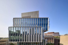
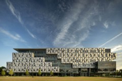
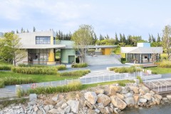
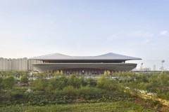
自2011年以来,Snøhetta一直致力于为MAX IV实验室开发独特的景观设计。MAX IV实验室景观位于瑞典南部隆德市,旨在为高性能同步辐射实验室MAX IV创建功能性景观解决方案。MAX IV是瑞典研究委员会和隆德大学联合运营的国家实验室。同步加速器设施由FOJAB建筑师创建,Snøhetta设计了19公顷的景观公园。MAX IV于2016年6月21日正式开放。景观设计基于一组独特的参数,以支持实验室研究的执行,包括缓解附近公路的地面振动、雨水管理和实现城市雄心勃勃的可持续发展目标等措施。
Since 2011, Snøhetta has been working on the development of a unique landscape design for the MAX IV Laboratory. Located in the city of Lund in southern Sweden, the MAX IV Laboratory Landscape is designed with the aim of creating a functional landscape solution for the high-performance synchrotron radiation laboratory MAX IV. MAX IV is a national laboratory operated jointly by the Swedish Research Council and Lund University. The synchrotron facility is created by FOJAB architects, and Snøhetta has designed the 19 hectares landscape park. MAX IV was officially opened on June 21st 2016. The landscape design is based on a set of unique parameters to support the performance of the laboratory research, including measures such as mitigating ground vibrations from nearby highways, storm water management, and meeting the city’s ambitious sustainability goals.

© ABML4

© Mikal Schlosser

© Cecilia Holm

© Cecilia Holm

© Mikal Schlosser

© Mikal Schlosser

© Mikal Schlosser

© Mikal Schlosser

© Mikal Schlosser

© Mikal Schlosser

© Snøhetta

© Snøhetta

© Mikal Schlosser

© Mikal Schlosser

© Mikal Schlosser

© Cecilia Holm

© Cecilia Holm

© Cecilia Holm

© Snøhetta

© Mikal Schlosser

© Snøhetta

© Snøhetta

© Snøhetta

© Snøhetta

© Snøhetta
MAX IV是隆德东北部地区更大改造的第一部分,旨在将农业用地转变为“科学城”。创建一个新的绿色公共公园,而不是一个封闭的、内向的研究中心,在公共领域产生了不同。MAX IV场地是一个绿色场地,山坡上的草甸植被作为休闲区的形象为研究设施的室外区域设定了新的标准。MAX IV是与客户、顾问和施工开发商合作的过程。
The MAX IV is the first part of a larger transformation of the area northeast of Lund aiming to turn agricultural land into a ‘Science City’. The creation of a new, green public park rather than a fenced, introverted research center makes a difference in the public realm. The MAX IV site is a green site, and the image of the meadow vegetation on sloping hills as a recreational area is setting a new standard for research facilities’ outdoor areas. MAX IV has been a collaborative process together with the client, consultants and construction developer.
The development of the landscape architecture design is based on four important criteria:
1 – Mitigating ground vibrations
Testing led by researchers and engineers revealed that traffic on the neighboring highway (E22) was causing ground vibrations that could in uence the experiments in the laboratories. By creating slopes and a more chaotic surface, the amount of ground vibrations has been reduced.
2 – Mass balance
为了优化现场开挖块的再利用,采用了挖填策略。这确保了在同步加速器不在现场时将土地转为农业用途的选择。通过将数字3D模型直接上传到GPS控制的推土机中,我们能够将这些物体重新定位到它们的位置
With focus on optimizing the reuse of the excavated masses on site, a cut and fill strategy was employed. This secures the option of reversing the land to agricultural use when the synchrotron is no longer on site. By uploading the digital 3D model directly into the GPS-controlled bulldozers, we were able to relocate the masses to their
nal position in one operations, and no masses were transported off site.
3 – Storm water management
The city planning department of Lund restricts the quantity of water permitted to run into the city’s pipelines, and water management inside the site’s boundaries. Dry and wet ponds are therefore designed for both the 1-year and the 100-year storm water.
4 – Plant selection and maintenance
The discovery of the nearby natural reserve area at Kungsmarken made it possible to use a selection of natural species by harvesting hay and spreading it on the new, hilly landscape. The maintenance strategy includes a combination of grazing sheep and conventional machines suitable for meadow-land.
Wavelengths and process
在MAX IV实验室现场,地面振动通常由高度在10到40米之间的波长产生,并沿着地面进行。地势越平坦,这些振动就越有可能干扰实验室的科学实验。这一知识引发了众多土堆的分布,以创造理想的不均匀地形,形成大胆的模式,管理现场的径流和质量平衡。事实证明,三维建模至关重要,原因有几个。通过将振动的性质提取到插入通用模型(蚱蜢;Rhino插件)。在平面图中,从主储存环辐射的相交切线构成了波型的第一个基础。这些与未来潜在实验室的位置一致,起点由10到40m的振动波长和4.5m的振幅确定。动力学小组强调,波的混沌组合越多越好。
On the MAX IV Lab site, ground vibrations are commonly created by wavelengths between 10 to 40m in height and follow the surface of the ground. The flatter the landscape, the more likely these vibrations will interfere with the scientific experiments in the laboratories. This knowledge initiated a distribution of numerous mounds to create a desired uneven topography, leading to a bold pattern, manage the water run-off and mass balance on site. 3D-modelling proved crucial for several reasons. The design layout was established by extracting the nature of vibrations into rational values inserted in a generic model (Grasshopper; a Rhino plug-in). In plan, intersecting tangents radiating from the major storage ring form the first basis of the wave pattern. These align with the positions of potential future laboratories, and the starting points were de ned by 10 to 40m vibration wavelengths and a 4.5m amplitude. The Dynamics group stressed the fact that the more chaotic combinations of waves, the better.

© Snøhetta
第二组波由以储存环为中心的螺旋运动与场地边界合并而成。我们的数字模型能够连续测试该模式对减轻地面振动的效果。从高级几何到制造的这一步仍然是我们今天在设计中面临的最大挑战之一。在MAX IV中,这个过程就像一台巨大的3D打印机以1:1的比例制作项目。高科技的研究设施与低技术的草地一起创造了波浪的标志性形象,保护研究设施免受振动。数字模型通过机器操作员的手得到最终的模拟解释,并由绵羊维护原生草地,以讲述这个研究实验室有趣而实用的故事。
A second set of waves was established from a spiral movement centered in the storage ring merging with the site boundary. Our digital model enabled continuous testing of the pattern’s effect on mitigating the ground vibrations. The step from advanced geometry to fabrication is still one of the largest challenges we face in design today. In MAX IV, the process was like having a giant 3D printer producing the project on a 1:1 scale. The high-tech research facility together with the low- tech meadowland creates the iconic image of the waves that protects the research facility from the vibrations. The digital model gets a final analog interpretation through the hand of the machine operator and native meadow grasses maintained by sheep to tell a fun and functional story of this research laboratory.
Jenny B. Osuldsen, Snøhetta, at the first Landezine LIVE: