联合国教科文组织世界遗产杰林
UNESCO World Heritage Site Jelling
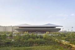
阿基特克丽丝汀·詹森·特格内斯图:在杰林的中间,两个土堆覆盖着青草,雄伟地向天空升起。在土堆之间矗立着两块巨大的符文石和一座粉刷过的中世纪教堂。这些纪念碑反映了一个时代,在那里,杰林是王室权力集中的纪念区,并拥有丹麦历史上最重要的时期之一:在这里,哈拉尔将英国统一为一个基督教国家。新的重大发现:一道栅栏、三座长屋和一艘来自900多人中间的石船,为关于吉林作为维京人时代的霸主和丹麦的摇篮的故事注入了新的活力。通过一个简单的景观建模,该纪念碑遗址项目旨在识别和传达这些新发现和现有世界遗产——包括Thyrashøj、Gormshøj、Jelling教堂和Jelling石头。
Arkitekt Kristine Jensens Tegnestue:In the middle of Jelling, two mounds covered in grass, rises majestically towards the sky. Between the mounds stand two giant rune stones and a whitewashed medieval church. The monuments tell off a time, where Jelling was a monumental area of centralized royal powerand holds one of the most essential periods in the history of Denmark: Here Harald Bluetooth united the kingdom in one Christian nation. New great discoveries: A palisade fence, three longhouses and a stone ship from around the middle of the 900-hundreds, have given new life to the story about Jelling as the Viking ages supremacy and as the cradle of Denmark. Through a simple landscape modeling, this project for the Monument Site is based on an intention to identify and convey these new findings and the existing world heritage – including Thyrashøj, Gormshøj, The Church of Jelling and The Jelling Stones.

© Jesper Larsen

© Kristine Jensens Tegnestue

© Kristine Jensens Tegnestue

© Kristine Jensens Tegnestue

© Kristine Jensens Tegnestue

© Kristine Jensens Tegnestue

© Kristine Jensens Tegnestue

© Kristine Jensens Tegnestue

© Kristine Jensens Tegnestue

© Kristine Jensens Tegnestue

© Kristine Jensens Tegnestue

© Kristine Jensens Tegnestue
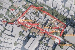
总体规划将过去和现在交织在一起,形成一个重要而难忘的地方。关闭戈姆斯韦沿线的交通有助于重新连接海盗时代的纪念碑和现代城市中心。这种关系构成了一个特色和吸引人的城市环境的基础,当地人和游客有机会探索历史或在宁静的环境中放松。纪念碑遗址本身是一个开放的绿色景观,可以作为当地跑步活动、学校远足和年度维京人集会的有利场所。与城市现有的广场、购物街和向南规划的新城市公园紧密相连,目标是加强当地商业,创造多样化的城市生活。
The master plan interweaves the past and the present to a significant and memorable place. Closing for traffic along Gormsvej contributes to the reconnection of the Viking ages monuments and the modern city center. This relationship forms the basis for a characteristic and attractive urban environment where locals and tourists have the opportunity to explore history or simply relax in the peaceful surroundings. The Monument Site itself is laid out as an open green landscape that advantageously can be used as a scene for local running events, school excursions and annual Viking gatherings. With a close connection to the city’s existing plaza, shopping streets and the new planned city park towards south, the objective is to strengthen local businesses and create a diverse city life.
The past in the present
杰林的纪念碑遗址可以被视为一个文本或一个翻版,其中包含了一层层的重要性。随着时间的推移,建筑物已被拆除、重新使用或重建;古老的果冻不断地被改写,并被新的部分取代。有了这些新的发现,一个隐藏的章节刚刚出现。今天的任务是沟通和处理这一历史层面,从而继续书写不断变化的杰林故事。
The Monument Site in Jelling can be regarded as a text or a palimpsest, which contain layers upon layers of importance. Through time buildings have been removed, reused or reconstructed; the ancient Jelling have continuously been rewritten and replaced with new parts. With the new findings, a hidden chapter has just seen the light of day. Today the task is to communicate and process this historical layer and thereby continue writing the ever-changing story of Jelling.
The Palisade
考古发掘表明,在Harald Bluetooth时代,修建了一道栅栏,平面图为360×360米。将土丘、凝胶体石和一些长屋和石船封装在一起的栅栏被放置成一个非常精确的平行四边形。几何研究表明,Harald Bluetooth的不同作品,包括Aggersborg、Fyrkat和Nordhøjen,可以写入这个平行四边形中的60米模块中。换句话说,栅栏是根据与哈拉尔·蓝牙其他作品相同的基本原理和测量方法建造的。不同之处在于形状和大小,这突出了凝胶的高度地位及其在维京人时代的重要性。360×360米的栅栏平面图用于确定新的纪念碑场地。在可能的情况下,它的规模和几何结构都得到了强调,表面和柱子都是轻质的、几乎是白色的混凝土。对表面进行处理的方式应确保栅栏围栏的初始横向构件具有下划线。这些柱子创造了一个明显的空间;它们勾勒出了绿色纪念碑遗址与石楠丛生植被和相邻耕地景观之间的重要边界。柱子成对升起,距离为60厘米。并按照当前的分点线切割,即23,4°。
Archaeological excavations indicate that in the time of Harald Bluetooth, a palisade fence was constructed with a floor plan of 360×360 meters. The Palisade that encapsulates the mounds, the Jelling stones, and a number of longhouses and stone ships, was placed as a very accurate parallelogram. Geometric studies show that the different works of Harald Bluetooth, including Aggersborg, Fyrkat and Nordhøjen, can be written into a 60 meter module in this parallelogram. The palisade has in other words been constructed after the same basic principle and from the same measurements as Harald Bluetooth’s other works. The difference is the shape and size, which emphasize the high status of Jelling and its importance in the Viking age. The floor plan of the palisade on 360×360 meters is used to define the new Monument Site. Its scale and geometry are emphasized – where it’s possible – with surfaces and pillars in a light, almost white concrete. The surfaces are being treated in a way so that the initial transverse elements of the palisade fence are being underlined. The pillars are creating an evident space; they outline a significant boundary between the green Monument Site with clusters of heather vegetation and the adjacent cultivated landscape. The pillars are raised in pairs with a distance on 60cm. and are cut in accordance with the current equinoctial line, i.e. In 23, 4°.
The Stone Ship and The Longhouses
这艘大型石船最初由一艘尖的椭圆形石船组成,中间是诺德赫延,在地形上以大型混凝土表面为标志。这些表面给人的印象是石船令人印象深刻的350×80米的几何形状和形状,以及草地和石南植物,景观中一个多事的开放道路系统。在一些发现原始石船碎片的地方,混凝土表面略微倾斜。相应地,三座长屋的位置将通过地形中的水平混凝土元素来描绘。在这些自然形成休息空间和活动平台的元素表面,房屋的发现和平面图以1:1的比例绘制。
The large stone ship, which initially consisted of a pointed oval stone ship, with Nordhøjen in center, is marked in terrain by large concrete surfaces. These surfaces give the impression of the stone ship’s impressive geometry of 350×80 meters and form, together with the grass and heather vegetation, an eventful and open path system in the landscape. In some places, where fragments of the original stone ship have been found, the concrete surfaces are being tilted with a slight inclination. Correspondingly, the position of the three longhouses will be portrayed through horizontal concrete elements in the terrain. On the surface of these elements, that naturally form space for a break and plateaus for activity, the findings of the houses and plan drawings are being drawn in 1:1.
The Monument Site in the City
为了在东北部的开放景观与西部和南部的更多城市区域之间建立紧密联系,杰林现有建筑之间的区域涂上了相同的光线,几乎是白色的混凝土。混凝土按照建筑比例进行布置,形成可理解的区域。因此,可以实现灵活性和功能性,并为日常生活和停车创造空间。混凝土、草和石南植物的普遍使用连接了整个区域,并定义了一个充满历史和记忆的景观城市中心。在这里,游客可以感受到过去防御工事的实际规模。在这里,游客可以探索杰林作为权力中心和丹麦诞生地的故事。在这里,居民可以在一个独特的纪念碑景观中放松或骑自行车。
In order to create a close connection between the open landscape to the north east and the more urban areas towards west and south, the areas between the existing buildings in Jelling are being coated with the same light, almost white concrete. The concrete is laid out in relation to the building proportions, forming comprehensible areas. Hereby flexibility and functionality can be achieved, and spaces for daily life and parking are created. The general use of concrete, grass and heather vegetation connects the entire area and defines a landscape city center filled with history and memory. Here the visitor can feel the physical magnitude of the past’s fortification. Here the tourist can explore the story about Jelling as a power center and the birthplace of Denmark. Here the inhabitants have the possibility to relax or bike around in a characteristic and unique monument landscape.
Data
实施日期:2013年
Project: The Monument Site of Jelling / UNESCO World Heritage Site
Location: Jelling, Denmark
Designers Landscape architect: Arkitekt Kristine Jensens Tegnestue
& artist: Ingvar Cronhammar
Client: Municipality of Vejle
Area: 13 ha
Cost: 3,2 mill. euro
Design 2008-2012
Implementation: 2013