克克拉德城市公园
City Park, Kerkrade
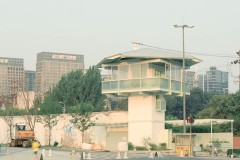
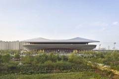
克尔克拉德的城市公园已被彻底翻新。今天,它是城市和乡村之间一个有吸引力的枢纽。这些年来,公园变得杂乱无章。B+B局重新安置了鹿园,并将一座陡峭的杂草丛生的山脊改造成了圆形剧场。小径结构已经改变,一条消失的小溪现在再次流过公园。地面污染带来了额外的挑战。
The City Park in Kerkrade has been drastically renovated. Today it acts as an attractive hub between the town and the countryside. During the years, the park had become disorganized. Bureau B+B relocated the deer park and transformed a steep overgrown ridge into an amphitheatre. The path structure has been altered and a vanished brook is now flowing through the park again. Ground pollution created an extra challenge.

© Frank Hanswijk

© Frank Hanswijk

© Frank Hanswijk

© Frank Hanswijk

© Frank Hanswijk

© Frank Hanswijk

© Frank Hanswijk

© Frank Hanswijk

© Frank Hanswijk

© Frank Hanswijk

© Frank Hanswijk

© Frank Hanswijk

© Frank Hanswijk

© B+B

© B+B

© B+B

© B+B
Renovation
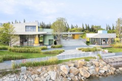
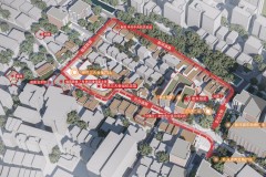
克尔克拉德的城市公园是在20世纪初以古典的英国景观风格设计的。这里有蜿蜒的小径、水景、树丛和鹿园。该位置以前的垃圾填埋场造成了显著的高度差异。城市公园是市中心、盖亚动物园、埃伦斯坦城堡和周围乡村之间的绿色枢纽。在过去的几年里,公园的几处扩建和改建已经使公园变得杂乱无章。B+B局受命将其打造成一个有吸引力的统一体。
The City Park in Kerkrade was laid out at the beginning of the 20th century in a classical English landscape style. There are winding pathways, water features, tree clumps and a deer park. A former landfill on the location creates a significant height difference. The City Park is a green hub between the town centre, the Gaia Zoo, Erenstein Castle and the surrounding countryside. Several additions and alterations have disorganized the park during the course of the years. Bureau B+B was commissioned to turn it into an attractive unity.
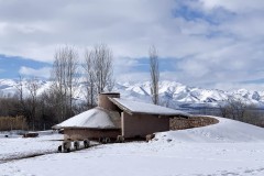
Brook
在过去,一条小溪曾经流过城市公园:尼尔斯普林比克。土地被填满,这条小溪被迫转入地下。今天,水又明显地流过公园。在公园的最高部分,水从一口“井”中涌出,这是一个流动的水池中的喷泉,上面有台阶。水从“井”流入公园的鹅卵石排水沟,沿着山脊的梯田向下流动。小溪流入公园越深,河道就越自然。这条小溪的尽头是公园最低处的一个池塘。小溪是一个连接的特征和好玩的对象。同时,它还控制周边社区的雨水排放。大雨期间,小溪变成了湍急的急流。
In the past, a brook used to run through the site of the City Park: the Nierspringbeek. The land fill forced this brook underground. Today, the water flows visibly through the park again. In the highest part of the park, the water springs in a ‘well’, a fountain in a flowing basin with stepping stones. The water flows from the ‘well’ into a cobble stone gutter through the park, downhill over the terraces of the ridge. The deeper the brook flows into the park, the more natural the watercourse. The brook ends in a pond at the lowest part of the park. The brook serves as a connecting feature and a playful object. At the same time, it regulates the drainage of rainwater from the surrounding neighborhoods. During heavy downpours, the brook turns into a raging rapid.
Spatial Unity
B+B局在Kerkrade遇到了一个被解剖的公园。一边是鹿园,阻挡了空间的统一,另一边是陡峭的山脊。鹿园被重新安置,山脊也从一个障碍物变成了一个待开发的地方。天然的石头边缘创造了像圆形剧场一样的梯田。茂密的植被被打开,可以看到全景。一个新的路径结构创建物理连接。入口的标记更加突出,使公园成为市中心、周边社区和乡村之间的天然路线。
Bureau B+B encountered a dissected park in Kerkrade. On one side the deer park blocked the spatial unity, on the other side a steep ridge. The deer park was relocated and the ridge was transformed from an obstacle into a place to be. Natural stone edges create terraces like an amphitheatre. The dense vegetation is opened up for a panoramic overview. A new pathway structure creates physical connections. The entrances are marked more prominently, making the park a natural route between the town centre, the surrounding neighborhoods and the countryside.
Soil Pollution
原填土的土壤受到污染。当土地填料仍在使用时,在倾倒下一层之前,垃圾被土壤覆盖。地面是50%的凋落物和50%的土壤的混合物。这意味着该场地并没有脏到必须清理的程度,但仍然太脏,无法挖掘。调整地形的唯一方法是增加土壤。这是一个挑战,以这种方式创造有吸引力的斜坡,同时保存尽可能多的树木。
The soil of the former land fill is polluted. When the land fill was still in use, the garbage was covered with soil before the next layer was dumped. The ground is a mixture of 50% litter and 50% soil. This means that the site is not so dirty that is has to be cleaned up, but still too dirty to excavate. The only way to adjust the relief, was to add soil. It was a challenge to create attractive slopes in this manner, while saving as many trees as possible.
Data
Completion date: September 2016
Location: Kerkrade, The Netherlands
Client: Municipality of Kerkrade
Designer: Bureau B+B
Area: 75.000 m2
Budget: : € 2.750.000,-
Photographer: Frank Hanswijk