普基亚湖国家战争纪念公园
Pukeahu National War Memorial Park
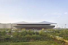
Wraight Athfield景观+建筑:Pukeahu国家战争纪念公园将现有国家战争纪念馆的影响延伸至惠灵顿市。折叠的梯田景观提供了一系列空间,支持纪念活动,同时方便行人、自行车手和车辆的日常活动。阿拉斯隧道为公园下的交通提供了一条主干道,在国家战争纪念馆前建立了一个大型中央广场。公园的文化和遗产价值的微妙分层以及开放空间的提供为进一步的城市修复和发展提供了催化剂。
Wraight Athfield Landscape + Architecture: The Pukeahu National War Memorial Park extends the influence of the existing National War Memorial into Wellington City. A folded, terraced landscape provides a range of spaces, supporting commemoration while facilitating the everyday activity of pedestrians, cyclists, and vehicles. Arras Tunnel provides an arterial route for traffic under the park, establishing a large central square in front of the National War Memorial. The park’s subtle layering of cultural and heritage values and provision of open space acts as a catalyst for further urban repair and development.

Site and Context
1932年,当国家战争纪念馆建成时,它的卡里隆塔使它非常显眼。修建一条林荫大道将纪念馆与科特奈广场连接起来的提议从未实现,它被孤立在一个半工业区内。2007年,文化和遗产部举办了一次公开设计竞赛,以创建新西兰纪念馆。2012年,宣布了开发普基亚湖国家战争纪念公园的计划,以纪念一战一百周年。这包括在巴克尔街的地下修建一个统一的纪念区,加强该地区的遗产价值,并确定中心城市的南部边缘。
When the National War Memorial was built in 1932 its carillon tower made it highly visible. The proposal to create a boulevard to link the memorial to Courtenay Place never eventuated and it became isolated in a semi-industrial zone. In 2007 the Ministry for Culture and Heritage held an open design competition to create a New Zealand Memorial. In 2012 the plan was announced to develop the Pukeahu National War Memorial Park to acknowledge the centenary of WWI. This included the undergrounding of Buckle Street to create a unified memorial precinct, strengthening the heritage value of the area and defining the central city’s southern periphery.

© Nathan Young

© Memorial Park Alliance

© Mark Herring

© Paul Fisher

© Nathan Young

© Nathan Young

© Nathan Young

© Nathan Young

© Mark Herring

© Paul Fisher

© WALA

© WALA

© Nathan Young

© Russell Kleyn

© Russell Kleyn

© Russell Kleyn

© Russell Kleyn

© Russell Kleyn

© Russell Kleyn

© Russell Kleyn

© Russell Kleyn

© Russell Kleyn

© Russell Kleyn

© WALA

© WALA

© WALA

© Russell Kleyn

© WALA
Landscape as Memorial
地形和时间被用作存储介质。公园的主要景观结构是地平面的塑造。山脊是微妙的弯曲和梯田提供了一系列的空间沿公园的长度。梯田反映了该地区先前的毛利人耕作方式,但也让人想起了帕塔山遗址周围的防御工事。尊重过去的古铜色,强化城市格网,建立种植模式和地形覆盖。
Topography and time are used as a media for memory. The primary landscape structure of the park is the shaping of the ground plane. The ridge is subtly warped and terraced to provide a range of spaces along the length of the park. Terraces are reflective of previous Māori cultivation practices in the area but also recall fortification forms surrounding hill Pa sites. The patina of the past is respected, the city grid strengthened, and established patterns of planting and landform overlaid.
阶梯式露台提供了一系列的景观房间,人们可以从一个房间搬到另一个房间。每个房间最终都会有自己的特色,插入新的花园、物体或基于场地的纪念物,但仍将是一段有凝聚力的旅程的一部分。折叠的平台墙形成隧道入口,让车辆乘员与上方的停车场接触。在国家战争纪念馆台阶的东侧和西侧是NgāTapuwae o te Kāhui Maunga花园,该花园是与te Atiawa代表密切合作设计的,te Atiawa代表是该地区的mana whenua。
The stepping terraces provide a series of landscape rooms designed so people can move from one to another. Each room will eventually have its own character with new garden, object or field based memorials inserted, yet will remain part of a cohesive journey. Folded down terrace walls form the tunnel portals to engage vehicle occupants with the park above. At the east and west sides of the steps to the National War Memorial are the Ngā Tapuwae o te Kāhui Maunga Gardens, designed in close collaboration with Te Atiawa representatives who are the mana whenua for this area.
Spaces for Procession and for Everyday Use
公园是游行和集会的通道。在诸如ANZAC日这样的场合,可能需要更宽阔的大道将游行队伍从周围的街道连接到国家战争纪念馆。更亲密的纪念活动可以聚集在公园内的特定“房间”。塔拉纳基(Taranaki)和托利街(Tory Street)大门处的建筑在游行可能暂停或开始的临界点提供了庇护所。对于车辆、步行或自行车交通,公园在城市中形成了一个“标点符号”,并提供了许多供人们使用的通道和公园房间。在大部分时间里,这个公园将是一个远离街道的休憩之所,一个美丽迷人的城市景观。
The park is a conduit for procession and assembly. Occasions such as ANZAC Day may call for the wider Boulevard to link a procession from the surrounding streets to the National War Memorial. More intimate commemorations can gather in specific ‘rooms’ within the park. The structures at the Taranaki and Tory Street gateways provide shelter at critical threshold points where processions may pause or begin. For vehicle, foot or cycle traffic, the park forms a ‘punctuation mark’ in the journey through the city and provides a number of pathways and park rooms for people to use. For much of the time this park will be a place for respite from the streets, a beautiful and engaging landscape within the city.
Data
面积:2公顷
Location: Buckle St, Mount Cook, Wellington, New Zealand
Project Team:
Landscape and Architecture: Wraight Athfield Landscape + Architecture
Engineering and Construction: Memorial Park Alliance
Signage Graphics : Base Two
Lighting Design : eCubed
Client : Ministry of Culture and Heritage
Illustrations: Stantiall Studio
Time frame: 2007 – 2015
Area: 2 ha