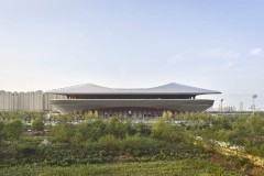
威留湿地公园
Weiliu Wetland Park
易方生态:渭河不仅是中国历史文学中著名的“长安八条河流”之一,也是黄河最大的支流,也是西安和咸阳市的“母亲河”。但随着这两座城市的城市化进程,曾经天然的渭河河岸地区逐渐被混凝土河岸和装饰性绿化植物所取代。河边野生景观的不断退化也导致了几代人生活在这个农村地区的人们失去了归属感。渭流湿地公园建在咸阳城外渭河漫滩的一段,这是为数不多的仅存的自然淹没河段之一。它长约3200米,宽470米,总面积125公顷。
Background: the mother river under pressure
Yifang Ecoscape: Wei River is not only one of the famous “Eight Rivers of Chang’an” described in Chinese historical literature and the biggest tributary of the Yellow River, but also the “mother river” of both Xi’an and Xianyang City. But as the urbanisation progress of these two cities, the once natural riparian areas of Wei River have gradually been replaced by concrete banks and decorative greenery planting. The constant degradation of the wild riverside landscape has also contributed to the loss of the sense of belonging, for the people who have lived in this rural area for generations. Weiliu Wetland Park was constructed on a section of Wei River’s floodplain outside of Xianyang City, which was one of the few naturally flooded river sections that remained. It is approximately 3200 m long and 470 m wide, with a total area of 125 ha.

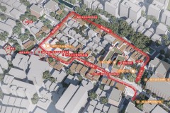
site location, existing conditions upstream and downstream
项目现场存在几个主要问题:紧邻上游的渭河天然漫滩已被工程混凝土堤岸取代,这给现场带来了更大的洪水压力。下游邻近地区也已城市化,但有装饰性种植,造成当地栖息地和生物多样性的重大损失。现场有几条粗挖的沟渠将雨水径流(有时是泄漏的污水)从城市输送到河流中,这不仅污染了河流本身,还污染了河岸水环境(当地采样显示河岸水水质低于国家地表水标准的V级)。最后,当地居民开垦了大片土地,用于荷塘和蔬菜种植,这表明人们对失去的农村生活方式有需求。
Issues: water pollution, ecological degradation and the gradual loss of rural landscape
The project site had several major issues: The once natural floodplain of the Wei River immediate upstream had been replaced by engineered concrete banks, which put more flood pressure on the site. The adjacent area downstream had also been urbanised but with decorative planting, causing a major loss of local habitat and biodiversity. There were several roughly dug ditches across the site carrying stormwater run-off (and sometimes leaked sewage) from the city to the river, which has polluted not only the river itself but also the riparian aquatic environment (local sampling showed riparian water quality worse than Class V of the National Surface Water Standards). Finally, local residents had reclaimed a large area of the site for lotus ponds and vegetable farming, which showed a demand for the lost rural lifestyle.

site before – existing earth dyke, deserted floodplain, stormwater ditch and reclaimed vegetable farms
为解决上述问题,项目的主要目标是全面恢复和重建当地漫滩生态系统。制定了一项计划,通过一系列战略创建城市绿色基础设施,包括适应性洪水控制、雨水管理、水质改善、废水再利用和生物多样性恢复,将现场改造成一个城市公园,提供环境和人的多重价值。
Overall Strategy: Creating integrated Green Infrastructure
To solve the issues described above, the comprehensive restoration and reconstruction of the local floodplain ecosystem was the main goal for the project. A plan was developed to create urban Green Infrastructure through a series of strategies including adaptive flood control, stormwater management, water quality improvement, waste water reuse and biodiversity restoration, which would transform the site into an urban park that provides multiple values on environment and people.

overall strategy

the master plan

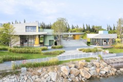
bird-eye view impression

reconstructed natural floodplain wetland
近年来,气候变化导致的频繁城市洪灾已成为一个全球性问题,渭河也面临着越来越大的洪灾压力,这是该项目的首要任务。为了恢复洪水滞留的弹性并利用漫滩空间,根据现有地形创建了一个适应性景观:最低区域设计为可淹没的自然湿地,洪水风险较低的区域用于人工湿地,现场最高区域用于休闲和娱乐空间。生物工程技术应用于公园内的所有防洪堤岸,但沿北部边界的现有外岸除外(为百年一遇洪水修建)。柳条护岸、抛石、石笼和草坡等技术被用于防洪、生物多样性恢复和栖息地保护。
Creating resilient, flood adaptive landscape
Frequent urban flooding due to climate change has become a global issue in recent years and Wei River has also suffered from increasing pressure from flooding, which is the project’s first priority. In order to restore the resilience of flood retention and utilize the floodplain spaces, an adaptive landscape was created based on the existing topography: the lowest areas were designed to be floodable natural wetlands, areas of lower flood risk were used for constructed wetlands and the highest areas on site were designated for recreational and leisure spaces. Bioengineering techniques were used on all flood control banks inside the park except the existing outer bank along the northern boundary (built for one in a hundred year flood event). Techniques such as willow mattress revetment, riprap, gabions, and grassed slope were used for flood protection, biodiversity restoration and habitat protection.

grassed banks for one in five-year flood protection

riprap banks for one in twenty-year flood protection

the outside bank and associated level change was utilized to create tiered gathering and leisure spaces
公园的主干是一条穿过公园中心的绿色走廊。它建在现有的土堤上,两侧是柳树。这些树木都保留了下来,很快成为新公园的一个独特景观。
Reusing the original dyke for green corridor
The main spine of the park was a green corridor that moved through the center of the park. It was built upon an existing earth dyke flanked by willow trees. The trees were all retained and quickly became a unique scenic feature of the new park.


retained existing trees flanking the central corridor make a unique scenic feature of the new park
Purifying waste water for reuse
In order to remove water pollutants and reuse waste water at the same time, a buffer belt of constructed wetlands was created between the city and the river. All polluted water from the drainage channels that ran through the site was firstly collected into WWTP. The constructed wetlands were designed for treating outlet water from a WWTP, and producing recycle water that meet Class III-IV standards using for landscape irrigation, the aquatic playground and finally directed to replenish the natural floodplain wetlands. The design of the constructed wetlands was based on the post-treatment water quality targets of Class IV standards and used subsurface wetlands primarily with supplementary surface wetlands. Oxidation lagoons were also added to the process for flood buffering, reoxygenation and water distribution.

a comprehensive water management plan

constructed wetlands also provide opportunities for environmental education and experiences
成功恢复栖息地的关键是利用大自然自身的再生能力。在清除了大部分正在进行的人为干扰(如垃圾倾倒和挖沙)后,该项目将目标设定为重建多样化的当地栖息地。利用现有的树木和野生芦苇池作为基础,设计应用小土法和精心的地方树木、灌木和水生植物的移植,以恢复水生生物、两栖动物和鸟类的避难所和栖息地。
Assisting natural recovery process
The key for a successful habitat restoration is utilizing nature’s own regenerative power. After removing most of on-going human disturbances such as rubbish dumping and sand dredging, the project set its goal on recreating a diverse local habitat. Using existing trees and wild reed ponds as a foundation, the design applied minor earth shaping and careful replanting of local trees, shrubs and aquatic plants to restore shelters and habitats for aquatic life, amphibians and birds.

the power of nature’s own ability to recover

recreating natural riparian wetlands by minor earth shaping

return of local birds after habitat reconstruction
为了满足当地对乡村和自然活动的需求,公园内包括了休闲区,如民用广场、水上游乐场、城市农场和乡村健身区,并融入了当地文化元素。该设计以水为主题,为附近居民和公园游客提供了大量机会,让他们返回并体验恢复后的漫滩地区。
Returning of rural lifestyle and natural experiences
In order to satisfy local demands for rural and natural activities, leisure areas such as civil squares, aquatic playgrounds, urban farms and rustic fitness zones were included in the park with a touch of local cultural elements. Using water as the main theme, the design gave nearby residents and park visitors plenty of opportunities to return and experience the restored floodplain area.

children were having fun in the aquatic playground

wetlands were the best places for exploring nature

many visitors were attracted by the wetlands everyday

small dams re-oxygenates water for the wetland and at the same time became a play feature

there were larger spaces designed for gathering and resting within the park
Creating artistic experience in nature
One of the artistic elements was expressed through two coloUrful bridges in the wetland area. The two intertwining structures raised and lowered through the landscape, forming boardwalks, bridges and viewing platforms, which symbolized the integration of water and the local culture.

colorful landscape bridges at night

intertwining bridges symbolizes the integration of water and local culture

design details of the bridge and boardwalk
Low cost sustainable Landscape with high benefits
Social and economic benefits were carefully considered at the very beginning of the project, which aimed at maximizing the project’s benefits while keeping the construction and maintenance costs down. After the completion of the project, a thorough evaluation process was carried out in conjunction of Beking University, in order to determine the environmental and social performances of the park and provide valuable experiences for similar projects in the future.
建成一年后,整个公园的水质监测点均报告结果优于III-IV级标准。与公园建设前从现场原始雨水沟采集的水样进行比较。COD、NH3-N、TP和TN的水平分别降低了89.6%、98.4%、96.6%和79.5%,而处理后的总回用水量达到了2.4×10⁶m3/年。
One year after the its completion, water quality monitoring spots across the park all reported results better than the Class III-IV standards. Comparing to water sample took from the original stormwater ditches on site before the construction of the park. The levels of COD, NH3-N, TP and TN in the water had shown a reduction of 89.6 %, 98.4 %, 96.6 % and 79.5 respectively while the total quantity of water reused after treatment reached 2.4×10⁶ m3 per annum.
成本效益研究表明,该公园的平均建设成本为每平方米80元人民币,不到咸阳当地同类公园的三分之一。关于本项目的环境效益,除上述水质改善外,公园不同区域的香农-维德纳指数(衡量当地生物多样性)平均得分提高到草本植物群落1.57-1.91分,树木群落2.11-2.33分。公众调查结果反映了公园的社会效益:在收到的462份有效问卷中,新公园的总体满意度为94%,其中老年人对舒适度、自然体验、儿童娱乐和休闲活动的满意度分别为90%、86%,分别为77%和80%。最后,附近居民报告说,公园建成后,邻近地区的房地产价值有所增加,但在现阶段,公园的实际经济效益难以衡量。
Cost-benefit study showed the average construction cost for the park was RMB80 per m2, which was less than one third of similar local parks in Xianyang. As regarding the environmental benefits of the project, in addition to the improvements in water quality mentioned above, the average scores for different areas of the park on the Shannon-Widener Index (measuring local biodiversity) were improved to 1.57-1.91 for herbaceous plant community and 2.11-2.33 for trees community. The social benefits of the park were reflected in the results of a public survey: out of the 462 valid questionnaires received, the overall satisfaction rate for the new park was 94%, in which the satisfaction rates for comfort, experiences of nature, children’s recreation and leisure activities for the elderlies were 90 %, 86 %, 77 % and 80 % respectively. Lastly, nearby residents reported an increase in real-estate values of the adjacent areas after the park’s completion, though actual economic benefits of the park were less measurable at this stage.

summary of key findings from the evaluation
绿色基础设施是提供综合生态服务的系统方法,具有多重效益。该项目在同一空间内集成了适应性洪水管理、人工湿地和栖息地恢复技术,将一个可洪水湿地区、一个雨水管理湿地和一个城市公园合并为一个魏柳湿地公园,并在此过程中提出了在城乡可持续发展进程背景下环境保护和生境恢复的良好范例。
Conclusion
Green Infrastructure is a systematic approach for providing comprehensive eco-services with multiple benefits. The project integrated adaptive flood management, constructed wetland and habitat restoration techniques within the same space, making a floodable wetland zone, a stormwater management wetland and an urban park all into the one Weiliu Wetland Park, and in the process raised a good example for environmental protection and habitat restoration on the background of sustainable rural-urban development process.
Restoring Wei River Floodplain – A resilient design for Weiliu Wetland Park
Design Firm: Yifang Ecoscape
Chief designers: Bo LUAN, Xin WANG
Design team: Yueyan JIN, Guoyan XIA, Xiaobin BAI, Xin FAN
Location: Xianyang, China
Time of Completion: May 2017
Area: 125 ha
Budget: RMB 80 million
Article written and edited by: Jianxi CHEN, Wenwei SHAO
Image credits: Yueyan JIN, Bo LUAN, Fang LI
Awards: Best of the Best Landscape Design Award, The 8th (2018) IDEA-KING International Landscape Planning & Design Competition